Product
Recommended article
- How Forestry Weather Stations Bolster Forest Fire Prevention Efforts
- Discover the Power of Negative Oxygen Ion Monitoring System for Cleaner Air
- Comparative Analysis of Ultrasonic and Automatic Weather Stations in Meteorological Monitoring
- Breaking Through the ‘Last Meter’ with Online Dust Monitoring System
- Mastering Road Conditions with Road Weather Station
- Inhalable Dust Continuous Tester: A Portable Solution for Dust Concentration Monitoring
Contact us
Shandong Fengtu IOT Technology Co., Ltd
Sales Manager:Ms. Emily Wang
Cel,Whatsapp,Wechat:+86 15898932201
Email:info@fengtutec.com
Add:No. 155 Optoelectronic Industry Accelerator, Gaoxin District, Weifang, Shandong, China
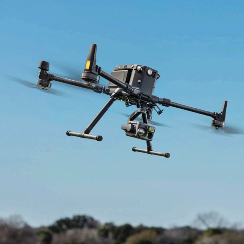
Drone solar panel inspection
Model:FT-EL4
Brand:fengtu
Related products
1.Drone solar panel inspection product introduction
Drone solar panel inspection Drone solar panel inspection is used to photograph solar panels to detect solar panel failures in photovoltaic power stations.The photovoltaic drone EL detector is used for the quality inspection of EL internal defects of array components in photovoltaic power stations. This system can quickly and efficiently complete the quality inspection of photovoltaic power stations, and can switch between photo mode and video mode for third-party operation and maintenance quality inspection. It can switch between multiple modes of detection with full automatic focus, making it the preferred equipment for power station inspection and operation and maintenance inspection.
The equipment uses the (M300 RTK) drone, which has a single flight time of up to 55 minutes, providing a stable and reliable high-performance flight platform for third-party industry drone applications. The 3-hour MW-level photovoltaic power station EL hidden crack inspection allows workers to say goodbye to tedious and repetitive low-value labor, greatly improving work efficiency. With the help of drone technology, the electric knife work automation process can be realized, effectively reducing operation and maintenance costs. At the same time, it can be used as an agent for personnel to perform high-altitude and high-risk environment operations, making EL detection safer.
2. Application fields of Drone solar panel inspection
Water power station, mountain power station, rooftop power station
3. Drone solar panel inspection efficiency
1 string/30 seconds (video), 1 string/40 seconds (photo); 1MW/3 hours (video), 1MW/4 hours (photo)
4. Defect types detected by drone solar panel inspection
Hidden cracks, broken grids, fragments, debris, splinters, backboard scratches, hot spot attenuation
Cold solder joint, sintering, black core piece, black edge, process pollution, edge overcut, short circuit/open circuit
Edge collapse, corner chipping, mixed file, attenuation, Pid, mismatch, tape piece
5. Drone solar panel inspection product advantages
1. Advantages of drones
M300 PTK is safer and more reliable with long-lasting flight
The device uses the top drone (M300). As a top drone manufacturer, the M300 RTK has higher flight stability and reliability. The lightweight design of the M300 can carry an all-weather large-load moving knife system with a long battery life of up to 55 minutes, and relies on the new OcuSync industry version of the image transmission system, which brings a control distance of up to 15 kilometers and three-channel 1080P high-definition image transmission. The drone is equipped with 2.4/5.8GHz dual-channel communication, which can automatically switch to the best channel in real time during the inspection process. It can still effectively resist interference in complex environments. It is equipped with AES-256 image transmission encryption technology to always ensure data transmission security, support LTE backup links, and further improve the reliability of image transmission. The entire system has higher performance stability.
Efficient and professional all-in-one aerial photography solution
The M300 drone adopts a modular design. The efficient moving blade system integrates dust and rain protection, active heat dissipation functions, and provides a maximum wind resistance of 15 meters per second. After being equipped with a drone EL detection gimbal camera, it can provide up to 50 minutes of endurance detection and 45 minutes of hovering monitoring. It only takes 40 minutes to fully charge a single battery, and 3 batteries can achieve uninterrupted EL inspection and testing of photovoltaic power stations.
2. Advantages of EL inspection
15KM GPS inspection flight
The device provides ultra-long battery life and long-distance real-time battery life detection with a maximum range of 15 kilometers. At the same time, the high-precision GPS route planning function, combined with a fully automatic optical zoom camera, makes unmanned intelligent inspection of photovoltaic power stations possible.
3. High-power imported EL power string power supply
EL string power supply is the core equipment of the whole system. It not only determines the imaging clarity but is also an indispensable part of efficient EL full inspection.
The power system of this equipment can perform power-on tests on multiple strings of EL at the inverter/combiner box. The power supply has a built-in programmable temperature control system to ensure that the temperature of the power supply is below the safe range of 50°C for long-term use. At the same time, the digital control panel greatly reduces the risk of human contact and can better ensure the safe use of operators.
4. Advantages of EL Camera
50Hz high frequency imaging
The EL camera on this device uses a German high-frequency InGaAs infrared chip and has a more excellent infrared sensor, which provides hardware guarantee for the clear image quality of EL detection. The high-frequency imaging technology can provide clear and thorough dynamic videos and aerial photos of internal defects of photovoltaic modules when the drone is flying.
Full-time auto focus in low light
An accurate focusing system is the core requirement for EL imaging, and the clarity of the image is determined by it. The EL camera of this device relies on the independently developed infrared lock relative focus system, which enables the device to perform real-time fully automatic zooming during the drone inspection process, freeing the drone EL aerial photography detection from the troubles of follow-focus devices and fixed-point flight.
5. Software advantages
Video processing software
For drone video inspection mode, EL cameras can save a variety of optional video formats, and the software can enhance the video quality and extract single-frame images to facilitate user report compilation and analysis
Image processing software
For drones in hovering photography mode, the EL camera can take multiple continuous shots and save multiple EL images at the same time. The software can be used to synthesize and process them to generate clearer images of internal defects in components.
Cloud management system (optional)
Our online cloud system has the functions of image storage, data storage, power station operation and maintenance data management, power station inspection report generation and export, automatic identification, power station information management, power generation evaluation and PR system efficiency value calculation.
Automatic defect recognition (optional)
The EL automatic identification software relies on the online cloud processing system. Users can independently conduct Ai identification learning and generate exclusive identification modules. They can also select existing identification modules to identify internal defects of photovoltaic modules. The identification types include broken pieces, fragments, hidden cracks, short circuits, attenuation, etc.
6. Drone solar panel inspection technical parameters
| Photovoltaic UAV testing equipment performance | |
| Drones | M300 RTK |
| EL PTZ Camera | LX101 |
| Logger | Based on IOS system, run EL camera and store corresponding data |
| Remote control with screen | Remote control aircraft, gimbal, infrared camera and visible light camera, can adjust camera-related configuration parameters, display screen to view real-time detection images, can control the switching of photo and video functions, |
| Drone positioning | GPS; GLONASS; BeiDou; Galileo |
| Drone Battery | WB37 |
| flight duration | 55 minutes |
| DJI M300 Drone | |
| Dimensions | 430mm*429mm*430mm (propeller, folded arms, with landing gear); |
| weight | 10kg (including 6 TB48S batteries) |
| Recommended maximum takeoff weight | 6.3kg |
| working frequency | 2.4GHz ; 5.8GHz |
| RTK position accuracy | 1cm+1ppm (horizontal) 1.5cm+1ppm (vertical) |
| Hovering accuracy | Vertical: ±0.1m Horizontal: ±0.1m, Pitch axis: 300°/s, Heading axis: 100°/s |
| Maximum pitch angle | 30° |
| Maximum ascent speed | 6m/s |
| Maximum descent speed | 5m/s |
| Maximum wind speed | 15m/s (Wind force 7) |
| Maximum horizontal flight speed | 65km/h (windless environment) |
| Maximum flight altitude | 7000m |
| Maximum flight altitude | 5000m |
| Hover time | No load: 55min Load: 45min |
| IP protection rating | IP45 |
| Visual obstacle avoidance perception range | Front, back, left, and right: 0.7 to 40m, up and down: 0.6 to 30m |
| Infrared obstacle avoidance sensing range | 0.1~8m |
| Up and down fill light | 5m |
| FPV Camera | 960P |
| Working temperature | -20°C to 50°C |
| PTZ parameters | |
| Wireless access | 2.4GHz |
| Working current | Static 300mA (16V); Dynamic 600mA (16V) |
| Operating temperature | -20~50℃ |
| weight | 900kg (280W*370D*340H) |
| Angle jitter | ±0.02 |
| Maximum controllable speed | Rotation angle 200°/s; pitch direction 100°/s; lateral direction 30°/s |
| Controllable rotation range | Rotation angle 360°; pitch direction ±450°; lateral direction 30°/s |
| EL Camera | |
| Product Specifications | Optimizing equipment for photovoltaic testing |
| Component Type | Crystalline silicon modules/thin film modules CIGS |
| Infrared resolution | 4000 x 2500 |
| Detection Mode | UAV mounting detection |
| Defect location | Satellite coordinate positioning can accurately navigate and find each defective component |
| EL working distance | 1~30m |
| Focusing method | Fully automatic focus |
| Spatial accuracy | 0.1 mm/pixel |
| Spatial resolution | 1.3 mRad |
| Clarity | 4K clarity |
| Scanning efficiency | 3h/1MW |
| Photo shooting efficiency | 5h/1MW |
| Maximum detection range | Single component scanning/12 component imaging |
| Field of view | 45°×45° |
| Accuracy | 1mm |
| Wireless Module | Long-band 5G wireless module |
| Power-on method | Multi-component power supply/string power supply/combiner box power supply |
| Power supply | 1) String type 15kw programmable power supply 2) Voltage 0~1500v; Accuracy ±0.1% 3) Current 0~10A; Accuracy ±1% 4) Current and voltage panel button settings 5) Constant current and voltage settings, one-button power-on, no adjustment required 6) Program-controlled constant temperature 7) Weight < 25kg With program control, constant current, voltage division, buffering, anti-reverse current, anti-static, anti-short circuit, anti-overload, anti-leakage |
| Infrared measurement and control technology | Users can directly scan the entire component or local internal defects through real-time images |
| Streaming video output | USB to PC, HDMI to compatible HDMI display, 6000 resolution |
| Video format output | MOV |
| Image format output | JPEG |
| EL image processing software | Image gain, defect marking |
| EL video processing software | Video editing, frame extraction, gain |
| User Interface | Chinese/(English optional) |
| Night vision function | have |
| Equipped equipment | Mobile phone/tablet/computer |
| WIFI CONNECTIVITY | Can realize mobile phone/tablet wireless APP operation |
| Data cable connection | Can realize PC operation to expand more functions |
| Usage Environment | night |
| size and weight | 13*15*11 (cm); 500g |
| Flight control system | |
| Basemap modeling | Power station map can be set for map modeling |
| Waypoint flight | Automatically fly according to the planned trajectory and automatically take photos at each waypoint |
| GPS automatic inspection | Can conduct GPS automatic flight inspection for internal defects based on map modeling |
| Dot positioning | The defective component location can be shared to other online platforms |
| Dual control switching | Quickly switch the control permissions of the two remote controllers |
| Hot shoe function | The battery is automatically heated; the aircraft battery can be switched without shutting down. |
| Breakpoint Continuation | After the drone returns to replace the battery, it can return to the place where it was disconnected to continue its inspection mission |
| Image processing software | |
| Video processing functions | Editing, frame extraction, watermarking, video synthesis |
| Image processing function | Clipping, watermarking, image synthesis |
| Satellite positioning function | The GPS location of each EL image can be extracted and a list can be generated to facilitate navigation to the defective component location |
| Optional | |
| Cloud Processing and Recognition Platform | EL automatic cruise detection |
| EL images automatically identify defects and automatically generate inspection reports | |
| Batch analysis of EL images and recognition processing | |
| Automatically generate a GPS location list of components with internal defects and navigate via mobile phone software | |
| Thermal Imaging | H20T |
Related article
-
Meteorological equipment for disaster prevention and mitigation
2024-03-01 -
How many parameters can a park anion monitoring system measure?
2024-07-24 -
Advantages of the box-type radar speedometer
2024-01-22 -
Advantages of Negative Oxygen Ion Monitoring Stations
2024-03-12 -
How to select sensors for four-element automatic weather stations?
2024-07-08 -
Combatting Dust: The Role of Dust Monitoring Equipment in Protecting Air Quality
2025-01-02 -
Intelligent agro-meteorological monitoring stations
2024-07-04 -
Road surface temperature monitoring station application range
2024-06-25


 Get a Free Quote